Introduction
Planning a navigation app can raise more questions than expected.
- Which map provider should you use?
- How accurate will the GPS be?
- Can your app recalculate routes when traffic changes?
- What happens when users lose their internet connection?
These decisions directly affect your navigation app development cost, timeline, performance, and user experience. The complexity increases when you add live tracking, voice guidance, location sharing, offline maps, or personalised routes.
If you are researching how to build a navigation app, start by defining the product around your users and their needs. You need the right navigation app features, reliable mapping and routing technologies, accurate location services, and a development plan that supports future growth.
Whether you want to build a consumer navigation app, a GPS tracking solution, or a specialised location-based product, your Android app development approach will depend on the problem you want to solve. AI can also support predictive routing, personalised recommendations, and natural language location search when these capabilities fit your product.
This guide covers the key features, technologies, development steps, challenges, AI opportunities, and costs involved in building a navigation app.
What Is a Navigation App and How Does It Work?
A navigation app helps users determine where they are, choose a destination, and follow a suitable route. It combines location data, digital maps, routing services, and mobile device capabilities to guide users from one point to another.
When you open a navigation app, the process starts with your device determining its current location. GPS provides positioning data, while mapping and routing services use that information to calculate a route. The app can then provide directions, estimate travel time, and update the journey when conditions change.
How GPS Navigation Works
A GPS navigation app typically follows this flow:
- Location detection: Your device receives signals from GPS satellites and estimates its position.
- Map matching: The app matches your location with a road, path, or other mapped area.
- Route calculation: A routing service evaluates available routes based on distance, travel time, road restrictions, and other conditions.
- Navigation guidance: The app displays the routes and can provide visual or voice instructions.
- Route updates: If you take a different road or traffic conditions change, the app can calculate another route.
The accuracy of this process depends on several factors. Buildings, tunnels, poor connectivity, device capabilities, and environmental conditions can affect location accuracy.
Navigation App vs GPS Tracking App
The two concepts are closely related, but their purpose differs.
| Navigation App | GPS tracking app |
|---|---|
| Helps users reach a destination | Monitors the location of a person, vehicle, or asset |
| Focuses on route planning and directions | Focuses on location history and real-time movement |
| Uses routing and navigation services | Uses continuous or scheduled location updates |
| Example: driving from London to Manchester | Example: monitoring delivery vehicles across the UK |
If you want to build a GPS tracking app, you may need features such as live location sharing, geofencing, movement history, alerts, and location-based reporting. A navigation product may need these capabilities too, but its primary purpose remains helping users plan and complete journeys.
What Features Does a Navigation App Need?
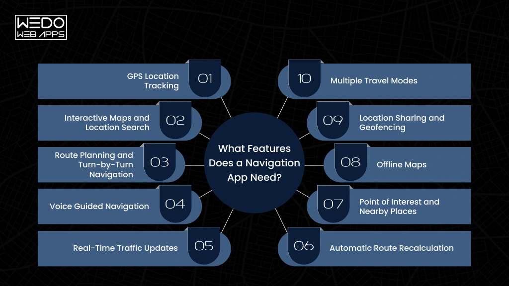
The features you choose should reflect how your users will navigate, what information they need during a journey, and how much control you want to give them. A basic navigation app may only need location tracking and route guidance. A more advanced product may need traffic intelligence, offline maps, location sharing, and multiple travel modes.
Here are the core navigation app features worth considering.
GPS Location Tracking
Your app needs to identify the user’s current position and update it as they move. Accurate location tracking is the basis for route guidance, distance calculations, and journey updates.
Example: A delivery driver can see their current position and track progress towards their destination.
Interactive Maps and Location Search
Users should be able to move around the map, search for addresses, and find relevant places. Search can include businesses, fuel stations, parking areas, restaurants, hospitals, or other points of interest.
Route Planning and Turn-by-Turn Navigation
Route planning helps users select a destination and find a suitable path. Turn-by-turn navigation then provides instructions throughout the journey.
You can also allow users to select preferences such as the fastest route, shortest route, or routes that avoid toll roads.
Voice Guided Navigation
Voice instructions allow users to follow directions without constantly looking at their screen. This is particularly useful for driving applications where reducing screen interaction can improve usability.
Real-Time Traffic Updates
Traffic information can help your app identify congestion and recommend alternative routes. If your product serves commuters or commercial drivers, timely traffic information can make navigation much more useful.
Automatic Route Recalculation
Road conditions can change during a journey. Users can also miss a turn or deliberately take another road.
Your app should be able to recognise the change and calculate a suitable route without requiring the user to restart navigation.
Point of Interest and Nearby Places
Location search becomes more useful when users can find relevant places around their current position or along their route.
For example, an electric vehicle navigation app could show nearby charging stations and indicate which ones are accessible along the planned route.
Offline Maps
Internet connectivity cannot always be guaranteed. Offline maps allow users to download selected areas and access essential navigation information when connectivity is limited.
This can be particularly useful for rural journeys, international travel, or areas with unreliable mobile coverage.
Location Sharing and Geofencing
Location sharing lets users share their current positions with selected contacts. Geofencing can trigger an action when a tracked device enters or leaves a defined area.
These capabilities are useful for fleet management, delivery services, family safety products, and other location-based app development use cases.
Multiple Travel Modes
Depending on your target audience, you may support driving, walking, cycling, public transport, or other travel modes.
You do not need to launch every mode at once. Start with the modes that directly support your core use case and expand them as the product grows.
How to Build a Navigation App
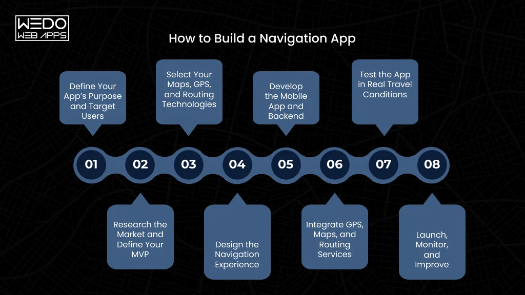
Building a navigation app requires more than integrating a map into a mobile app development interface. You need to plan the product, choose suitable location technologies, connect mapping and routing services, and test how the app performs in real travel conditions.
A practical navigation app development process can be broken into eight stages.
1. Define Your App’s Purpose and Target Users
Start with the problem your app needs to solve. Identify who will use it, where they will use it, and what type of journeys they need to complete.
Your requirements will differ based on the product you have in mind.
| App type | Primary requirements |
|---|---|
| Consumer navigation | Route planning, directions, traffic, and places |
| Fleet navigation | Live tracking, route optimisation, and geofencing |
| Delivery navigation | Multi-stop routing, ETAs, and driver tracking |
| Tourism navigation | Walking routes, landmarks, and offline maps |
2. Research the Market and Define Your MVP
Study established products such as Google Maps and Waze alongside apps serving a specific niche. Look at what they offer and where you target users who still face difficulties.
Then define your minimum viable product.
Your initial release could include:
- GPS location tracking
- Map and address search
- Route planning
- Turn-by-turn navigation
- Voice guidance
- Route recalculation
You can introduce advanced capabilities after validating the core product with real users.
3. Select Your Maps, GPS, and Routing Technologies
The technology behind your app affects its functionality, operating cost, geographic coverage, and future development options.
You may use a commercial mapping platform, an open mapping ecosystem, or a combination of specialised services.
For example, Google’s Navigation SDK supports in-app turn-by-turn navigation and lets mobile app developers configure navigation experiences within their applications.
Before choosing a provider, assess:
- Map coverage in your target locations
- Routing capabilities
- API and SDK support
- Usage pricing
- Licensing conditions
- Offline functionality
- Traffic and place data availability
The cheapest API is not always the most suitable option. Your choice should match the product you plan to operate.
4. Design the Navigation Experience
Navigation interfaces need to communicate information quickly. Users should understand their next turn, current position, route, and estimated arrival time without searching through menus.
Your UI/UX design should account for the context in which people use the app.
- For drivers: Prioritise clear route guidance, voice instructions, traffic alerts, and minimal interaction.
- For pedestrians: Give more attention to walking paths, landmarks, crossings, and nearby places.
- For fleet operators: Provide a separate view for monitoring vehicles, routes, stops, and driver activity.
Accessibility should also be considered from the beginning. Text size, colour contrast, voice guidance, and touch targets can affect whether users can navigate the app comfortably.
5. Develop the Mobile App and Backend
The mobile application handles the user-facing navigation experience. This includes maps, location updates, search, directions, permissions, notifications, and navigation controls.
The backend manages the information your product needs beyond the device.
Depending on your use case, this can include:
- User accounts
- Saved locations
- Journey history
- Location data
- Alerts
- Geofences
- Analytics
- Fleet or driver information
For a delivery platform, for example, the backend may receive driver locations and make updated ETAs available to customers and dispatch teams.
6. Integrate GPS, Maps, and Routing Services
This is where the core navigation capabilities come together.
Your development team may integrate GPS and device location services with mapping, geocoding, routing, traffic, and navigation APIs.
The exact combination depends on your product. A consumer app may need strong route guidance and place search. A fleet application may require frequent location updates, geofencing, and route monitoring.
You also need to handle permission states properly. Users should understand why location access is required and what functionality depends on it.
7. Test the App in Real Travel Conditions
Navigation testing should go beyond checking whether a route appears on a map. Your team needs to understand how the app behaves when real conditions become difficult.
Test scenarios should include:
- Weak GPS signals: Check whether the app can recover when location accuracy drops.
- Poor connectivity: Test route access and navigation behavior when the network becomes unreliable.
- Missed turns: Confirm that the app detects deviations and recalculates the route correctly.
- Long journeys: Monitor battery consumption, location updates, and application stability.
- Different environments: Test urban streets, tunnels, rural roads, and areas with complex road layouts.
This stage can reveal problems that are difficult to identify through standard functional testing alone.
8. Launch, Monitor, and Improve
Once the app is ready, launch it for your selected market and monitor how people actually use it.
Track metrics such as:
- Navigation sessions
- Route completion rates
- Search failures
- Recalculated routes
- App crashes
- Location permission acceptance
- User feedback
These insights can guide future development. If users frequently search for charging stations, for example, an EV navigation product could make charging locations more prominent.
You can then introduce additional capabilities such as personalised routes, advanced traffic predictions, location-based recommendations, or AI-powered features based on genuine user needs.
A successful launch is the starting point for improving the navigation experience as your users, coverage, and product requirements grow.
What Technology Is Used to Build a GPS Navigation App?
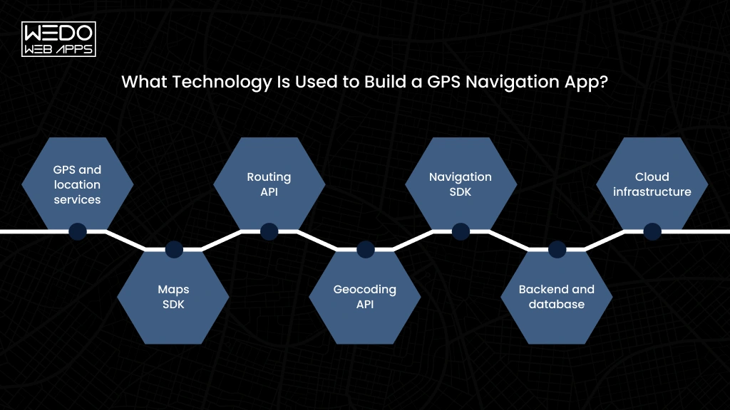
The technology stack behind a navigation app depends on the experience you want to deliver. You need more than a map API. Your app may require GPS services, routing, geocoding, navigation SDKs, cloud infrastructure, databases, and real-time data.
Here is how the main technology components fit:
| Technology | What it handles | Typical use |
|---|---|---|
| GPS and location services | Detects and updates the user’s position | Live location and journey tracking |
| Maps SDK | Displays interactive maps and map elements | Roads, markers, routes, and places |
| Routing API | Calculates routes between locations | Directions, ETAs, and alternative routes |
| Geocoding API | Converts addresses and coordinates, and vice versa | Address search and location lookup |
| Navigation SDK | Provides turn-by-turn navigation capabilities | Voice guidance, rerouting, and navigation UI |
| Backend and database | Stores and processes application data | Accounts, saves places, trips, and tracking |
| Cloud infrastructure | Supports scalable application services | Real-time updates and API processing |
GPS and Location Services
Your app relies on the device’s location capabilities to determine where the user is. The application can then use these updates for navigation, tracking, route progress, or location-based alerts.
The frequency of location updates should match the use case. A fleet tracking application may frequently update, while a simple nearby places feature does not need continuous tracking.
Mapping and Navigation APIs
Mapping platforms provide the underlying geographic data and services required to display maps and build navigation experiences.
Google’s Navigation SDK supports in-app turn-by-turn navigation, route configuration, multiple travel modes, and custom navigation experiences. It works alongside the Google Maps SDK for the map layers.
Mapbox provides Navigation SDKs for Android and iOS, along with services for directions, map matching, route optimisation, and other navigation requirements. Its current Navigation SDK supports capabilities such as rerouting, traffic, and closure avoidance, voice instructions, and online navigation.
The right provider depends on your product requirements. Compare geographic coverage, routing capabilities, customisation, offline support, usage pricing, licensing, and SDK support before making a decision.
Geocoding and Routing API
Geocoding connects human-readable addresses with geographic coordinates. Routing services then use coordinates and road data to calculate suitable journeys.
For example, when a user enters a postcode or business address, geocoding can identify the corresponding location. The routing service can then calculate a journey from the user’s current position to that destination.
For more advanced products, you may also need map matching, route optimisation, distance matrices, or isochrone services. Mapbox currently provides APIs covering these types of navigation requirements.
Backend, Database, and Cloud Infrastructure
Your backend becomes more important as your app moves beyond basic navigation.
You may need it to manage user accounts, saved destinations, trip history, location records, notifications, geofences, analytics, and business-specific data.
A fleet navigation platform, for example, could use the backend to receive driver locations and make them available to an operations dashboard in near real-time.
Mobile Development Technology
You can develop your navigation app separately for iOS and Android or use a cross-platform development approach where it suits the product.
Native development can provide closer access to platform-specific location and navigation capabilities. Cross-platform development can help share more application code between platforms.
The right choice depends on your required SDK integrations, performance expectations, development resources, and long-term product plans.
Real-Time Data and Third-Party Services
Advanced navigation products may also depend on external data sources for traffic, weather, public transport, parking, EV charging, fuel prices, and other location-based information.
Before integrating any third-party services, check its data quality, API limits, pricing, geographic coverage, and terms of use. These services can become an ongoing operating cost as your user base grows.
The key takeaway: choose your technology stack around the navigation experience you want to provide. Your development team should evaluate the complete architecture before selecting individual APIs or SDKs.
How AI Can Improve a Navigation App
AI can make a navigation app more responsive to changing road conditions and individual user behavior. The best approach is to use AI alongside your mapping, routing, and location systems rather than replacing them.
| AI capability | What it can do | Example |
|---|---|---|
| Predictive traffic and route planning | Analyse historical and live data to predict congestion | Suggest a different route before a busy road becomes heavily congested |
| Personalised route recommendations | Learn route preferences and travel platforms | Prioritise routes that avoid tolls or motorways |
| Natural language location search | Understand conversational destination requests | “Find an EV charger near a coffee shop on my route” |
| AI-based GPS anomaly detection | Identify unusual location or movement patterns | Alerts a fleet manager when a vehicle makes an unexpected stop |
| Smarter location recommendations | Recommend relevant places based on context | Suggest parking, fuel stations, or charging points during a journey |
Predictive Traffic and Route Planning
AI can analyse historical traffic patterns alongside current location and road data. This can help your app estimate where congestion may develop and recommend routes earlier.
For example, a commuter travelling through a regularly congested UK city route could receive an alternative before traffic builds up.
Personalised Route Recommendations
Different users have different route preferences. AI can learn patterns from previous journeys and use them to tailor recommendations.
A user who regularly avoids toll roads, for instance, could receive routes that match this preference without changing the same settings repeatedly.
Natural Language Location Search
AI can make location search more conversational. Users can describe what they need instead of entering an exact place or address.
A request such as “Find a quiet restaurant with parking near my destination” can be interpreted using location, place, and journey data.
AI-Based GPS Anomaly Detection
GPS data can contain unusual movements caused by signal problems, unexpected stops, or changes in travel patterns. AI models can help identify these anomalies.
This can be particularly useful when you build a GPS tracking app for fleets, logistics companies, or field teams.
Smart Location Recommendations
Your app can combine location, journey context, time, and user preferences to recommend relevant places.
For example, an EV driver nearing a low battery level could receive charging-point recommendations along the planned route.
Keep AI grounded in reliable data. Your Navigation system still needs accurate maps, GPS signals, routing services, and clear privacy controls. In the UK, location information can qualify as personal data, so your data collection and processing should account for UK GDPR requirements.
How to Build a Navigation App Like Google Maps?
Building a navigation app like Google Maps requires more than adding maps and GPS tracking. You need mapping data, routing, search, live traffic information, location services, and a user experience that can handle different travel situations.
You also need to decide how closely your product should match the capabilities of established navigation platforms. A focused product for one industry or user group can be far more practical than trying to reproduce every Google Maps feature.
Start With a Specific Navigation Use Case
Define what your app should do better or differently. For example:
- Local navigation: Help users find places and navigate around a specific region.
- Fleet navigation: Support drivers with route planning, tracking, and fleet visibility.
- Delivery navigation: Help drivers manage multiple stops and optimise delivery routes.
- Tourism navigation: Combine direction with attractions, tours, and local information.
- EV navigation: Recommend routes based on charging stations and vehicle range.
A clear use case helps you decide which navigation app features belong in the first release.
Choose Your Mapping and Routing Provider
Your mapping provider will influence how your application handles maps, directions, traffic, navigation, and location search.
Options such as Google Maps Platform and Mapbox provide SDKs and APIs for navigation applications. Compare them based on:
- Map coverage in your target markets
- Routing and traffic capabilities
- Turn-by-turn navigation requirements
- Offline navigation requirements
- API and SDK pricing
- Customisation options
- Licensing terms
- Platform supports
Build the Core Navigation Experience
Your first version should focus on the journey itself. Users should be able to search for a destination, select a route, start navigation, and receive updates as they travel.
Once the core experience works reliably, you can add features such as live traffic, saved locations, location sharing, personalised routes, POI recommendations, and AI-powered search.
Add Google Maps-Like Capabilities Gradually
A mature navigation platform can include many interconnected services. Instead of building everything at once, expand based on user demand.
For example:
- MVP -> Search, maps, GPS location, routing, turn-by-turn navigation
- Next release -> Traffic, rerouting, saved places, multiple travel modes
- Advanced -> Offline maps, location sharing, AI recommendations, predictive routing
Test in Real Travel Conditions
Navigation apps need testing beyond normal functional checks. Test your application while driving, walking, and travelling through areas with weak GPS or mobile connectivity.
Check route accuracy, GPS updates, rerouting speed, voice instructions, battery usage, and behaviour when connectivity drops.
The goal is not to copy every Google Maps feature. It is to build a navigation experience that solves a specific user problem reliably and gives you room to expand.
What Challenges Should You Consider When Developing a Navigation App?
Navigation apps depend on location data, mapping services, mobile connectivity, and real-time processing. Small issues in any of these areas can affect the user’s journey.
Here are the main challenges to consider during navigation app development.
GPS Accuracy and Location Drift
GPS signals can become less accurate around tall buildings, tunnels, underground areas, or dense urban locations. Your app should account for inconsistent location updates instead of assuming every GPS reading is accurate.
Map matching can also help align GPS coordinates with the correct road or route.
Real-Time Data and Route Changes
Traffic, road closures, accidents, and changing travel conditions can make an earlier route less suitable.
Your routing system should process relevant updates and recalculate routes without causing unnecessary changes during a journey.
Battery Consumption
Continuous GPS tracking can consume significant battery power, particularly when location updates run frequently in the background.
Use appropriate location update intervals and background processing strategies based on the app’s actuarial requirements.
Poor or Lost Connectivity
Users may lose mobile connectivity while travelling through rural areas, tunnels, or areas with weak coverage.
If your product requires reliable navigation in these situations, consider offline maps, cached routes, and locally available navigation data.
Location Privacy and Data Protection
Navigation apps can process sensitive location information, including travel patterns and frequently visited places.
If you operate in the UK, consider UK GDPR requirements when collecting, storing, sharing, and retaining location data. Give users clear information about how their data is used and provide appropriate controls.
Third-Party API Dependency
Maps, routing, geocoding, traffic, and other services may depend on external APIs. Changes to pricing, usage limits, coverage, or service availability can affect your application.
Choose providers carefully and understand their pricing and licensing terms before building your core product around them.
Accessibility and Usability
Navigation information needs to remain easy to understand while users are moving. Consider readable text, clear visual directions, voice guidance, accessible controls, and support for different user needs.
For UK products, accessibility requirements should also be considered where your organisation or service falls within applicable accessibility obligations.
How Much Does It Cost to Build a Navigation App?
The cost to build a navigation app depends on its features, mapping provider, platforms, backend requirements, and development team. A basic GPS navigation app will cost less than a platform with live traffic, offline maps, AI, fleet tracking, and advanced route planning.
For a typical navigation app, development cost can fall into those broad ranges:
| App type | Estimated development cost | Typical scope |
|---|---|---|
| Basic navigation app | £25,000 - £50,000 | GPS, maps, location search, basic routing |
| Mid-level navigation app | £50,000 - £100,000 | Turn-by-turn navigation, traffic, rerouting, accounts, saved places |
| Advanced navigation app | £100,000 - £200,000+ | Offline maps, live tracking, AI multiple travel modes, advanced backend |
These figures are indicative. Your actual navigation app development cost will depend on the product scope and technical choices.
What Affects Navigation App Development Cost?
- Features: Live tracking, offline navigation, voice guidance, geofencing, AI, and advanced route planning require additional development.
- Platforms: Building for both iOS and Android generally requires more testing and platform-specific work than supporting one platform.
- Maps and APIs: Mapping, routing, geocoding, traffic, and navigation services can introduce ongoing usage costs alongside development expenses.
- Backend Infrastructure: Apps that handle live tracking, user accounts, trip history, fleet data, or real-time updates need more backend infrastructure.
- UI & UX: A navigation interface needs careful design because users often interact with it while travelling. Clear layouts and accessible controls require dedicated design and testing.
- Testing: GPS behavior, route accuracy, connectivity changes, background tracking, battery usage, and different travel conditions all need real-world testing.
How to Control Development Costs
Start with an MVP that solves one clear navigation problem. Use established mapping and navigation services instead of building every mapping component yourself.
You can then add advanced capabilities based on user feedback and business requirements. This approach reduces initial app development costs while giving you room to expand the product over time.
How to Choose a Navigation App Development Company
Choosing the right development partner can affect your app’s accuracy, performance, scalability, and ongoing costs. Focus on practical experience rather than general mobile development capabilities.
Check GPS and Location-Based Development Experience
Look for a team experienced in GPS navigation app development, location tracking, geofencing, routing, and real-time location services. This experience helps Android app developers anticipate location-specific technical challenges.
Review Relevant Projects
Ask for case studies or examples of apps with similar requirements. Look for experience with navigation, fleet management, delivery travel, or other location-based app development projects.
Ask About Maps and API Integration
Discuss which mapping, routing, geocoding, and navigation APIs the team recommends. They should explain why a particular technology fits your users, locations, features, and budget.
Discuss Testing, Privacy, and Maintenance
Ask how the team will test GPS accuracy, route changes, connectivity issues, and background tracking. Also discuss location data protection, post-launch maintenance, API updates, and ongoing technical support before development begins.
Conclusion
Building a navigation app requires more than integrating GPS and displaying a map. You need reliable location services, accurate routing, useful navigation app features, and an architecture that can support real-time data.
Your priorities will depend on the product you want to create. A delivery app may need multi-stop routing, while a fleet solution may focus on tracking and geofencing. AI can add further value through predictive traffic, personalised routes, and smarter location recommendations.
Start with a clear use case and a better software development partner. Choose your mapping and navigation technologies carefully, test the app in real travel conditions, and plan for privacy, maintenance, and future growth.